 09-13-10, 07:09 PM
|
#1
|
Admiral 
Join Date: Apr 2005
Location: Dayton, Ohio
Posts: 2,292
Downloads: 474
Uploads: 64
|
[REL] 3000 Yard/Meter Bearing Plotter Tool
This is a rework of previous mods that dealt with an in-game bearing plotter for the Navigation and Attack Map screens. It is compatible for both American and German side of play, at either Metric or Imperial measurements (as long as you choose the correct edition), and at 8 "basic" game resolutions depending on your particular hardware and in-game settings.
 I take no credit for its design, or changes to the original made many years ago. My part was to rescale the device to accurately display for either Metric or Imperial measurements; to have it accurately scaled to the 8 "basic" screen resolutions, and to have these changes put into a thread that can be used by the submarine simulation community.
The 8 "basic" resolutions are:
1024x
1152x
1280x
1360x
1440x
1600x
1680x
1920x
When I state "basic", I'm referring to the basic family of Horizontal resolutions and "all" the Vertical resolutions used with it. Examples are the family of 1280x768, 1280x800, 1280x960, 1280x1024. The specific 1280x edition will work correctly with all the various Vertical resolutions of the 1280x family. In order to have a 3000 Yard/Meter Bearing Plotter the image has to be large to cover the native distance of the maps. This has made it necessary to create different editions for each resolution, and for each chosen unit of game measurement (Metric or Imperial).
They are all JSGME compatible and are linked at the following:
U.S. Customary Measurement (Imperial)
3000 Yard Bearing Plotter (1024x)
3000 Yard Bearing Plotter (1152x)
3000 Yard Bearing Plotter (1280x)
3000 Yard Bearing Plotter (1360x)
3000 Yard Bearing Plotter (1440x)
3000 Yard Bearing Plotter (1600x)
3000 Yard Bearing Plotter (1680x)
3000 Yard Bearing Plotter (1920x)
Metric Measurement
3000 Meter Bearing Plotter (1024x)
3000 Meter Bearing Plotter (1152x)
3000 Meter Bearing Plotter (1280x)
3000 Meter Bearing Plotter (1360x)
3000 Meter Bearing Plotter (1440x)
3000 Meter Bearing Plotter (1600x)
3000 Meter Bearing Plotter (1680x)
3000 Meter Bearing Plotter (1920x)
To install after downloading:
I take no credit for its design, or changes to the original made many years ago. My part was to rescale the device to accurately display for either Metric or Imperial measurements; to have it accurately scaled to the 8 "basic" screen resolutions, and to have these changes put into a thread that can be used by the submarine simulation community.
The 8 "basic" resolutions are:
1024x
1152x
1280x
1360x
1440x
1600x
1680x
1920x
When I state "basic", I'm referring to the basic family of Horizontal resolutions and "all" the Vertical resolutions used with it. Examples are the family of 1280x768, 1280x800, 1280x960, 1280x1024. The specific 1280x edition will work correctly with all the various Vertical resolutions of the 1280x family. In order to have a 3000 Yard/Meter Bearing Plotter the image has to be large to cover the native distance of the maps. This has made it necessary to create different editions for each resolution, and for each chosen unit of game measurement (Metric or Imperial).
They are all JSGME compatible and are linked at the following:
U.S. Customary Measurement (Imperial)
3000 Yard Bearing Plotter (1024x)
3000 Yard Bearing Plotter (1152x)
3000 Yard Bearing Plotter (1280x)
3000 Yard Bearing Plotter (1360x)
3000 Yard Bearing Plotter (1440x)
3000 Yard Bearing Plotter (1600x)
3000 Yard Bearing Plotter (1680x)
3000 Yard Bearing Plotter (1920x)
Metric Measurement
3000 Meter Bearing Plotter (1024x)
3000 Meter Bearing Plotter (1152x)
3000 Meter Bearing Plotter (1280x)
3000 Meter Bearing Plotter (1360x)
3000 Meter Bearing Plotter (1440x)
3000 Meter Bearing Plotter (1600x)
3000 Meter Bearing Plotter (1680x)
3000 Meter Bearing Plotter (1920x)
To install after downloading:
The files are compressed using WinRaR. Use WinRAR or a compatible application to "Extract" the "3000 Yard (Meter) Bearing Plotter" to the "MODS" folder of JSGME (in the root directory of Silent Hunter 4, Wolves of the Pacific folder). Activate the mod through the JSGME instructions. I recommend activation of the Bearing Plotter AFTER any other mods you have activated in JSGME. This will correctly have the mod run as intended.
It's note worthy that when or if you change the in-game graphic resolution, you must restart the game for the new resolutions to take effect. While at the Windows screen, this will be when you also activate in JSGME the correct edition for the resolution you've selected.
One of the problems of the past 1500 yard plotters is that at 1500 yards the target is very nearly ready to be fired upon, giving little time to use the plotter as intended (to help plan the attack). At 3000 yards/meters, more time is given due to the extended size of the tool.
Also something you will notice on the navigation screen is when the sub travels along its waypoint path the plotter will show 1 degree off center from the path of travel. This is not a problem with the plotter being incorrectly drawn. The plotter will come up 1 degree short to the right of center if you're heading turns right, or 1 degree short to the left of center if you're heading turns left. If anything this shows the plotter is dead on center. The problem is within the game code that for some reason comes up 1 degree short depending on which way you turn. We can't fix what the developers don't wish us to get our hands on!!
Besides the rescaling of the plotter for the various uses, I changed the Maps.cfg to include an additional zoom level and tweaked the Attack Map starting zoom level.
=============
Credit for the initial Bearing Plotter goes to Pato back in the SHIII days. CaptainCox, 13th4l, NoWonderDog, and Rockin Robbins have all had contributing work and revisions to the mod. Without their efforts I could not have completed my small part.
=============
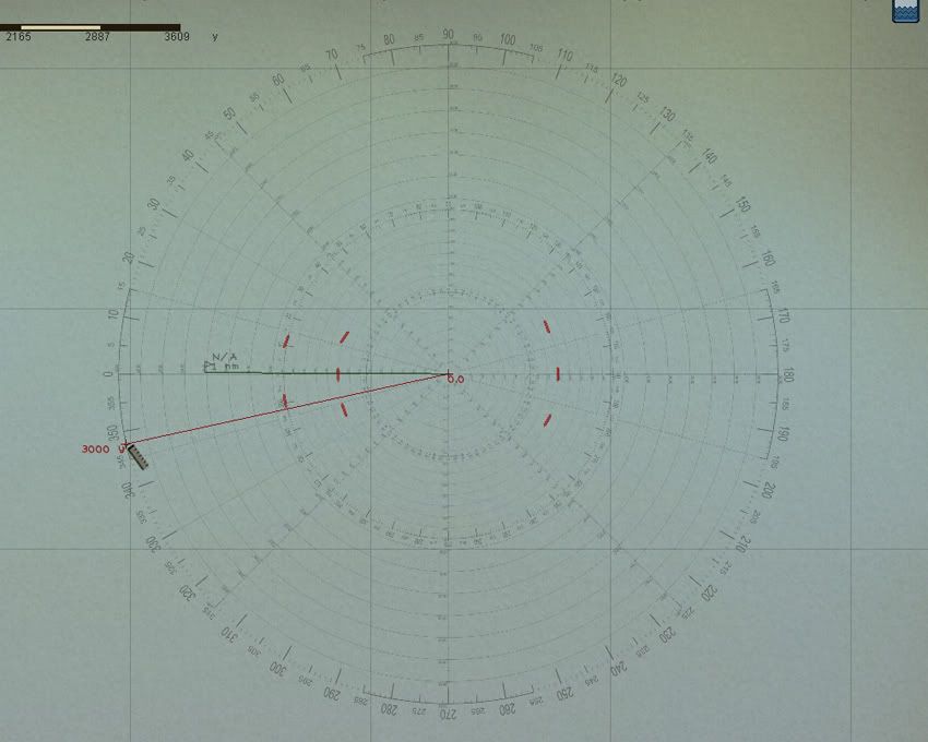
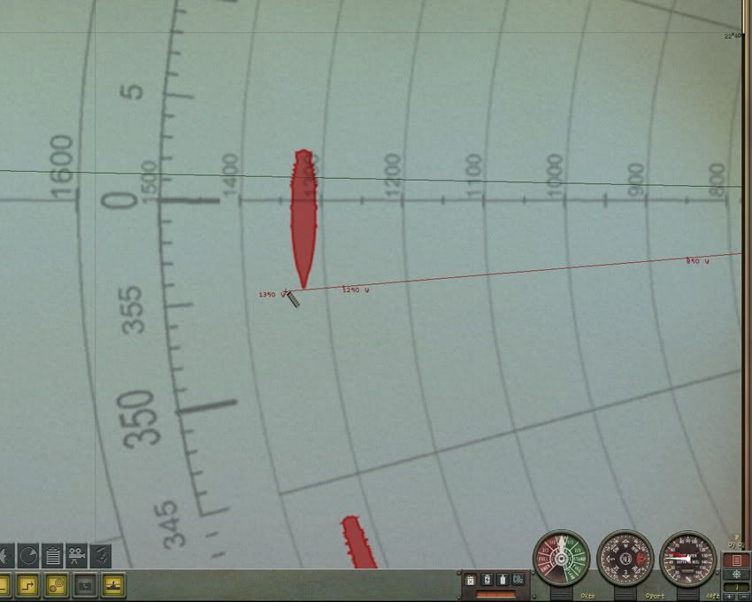
The following are in-game images. The first was taken with the game in a 1600x1200 resolution. I should point out the ruler is defined in 50 units of measurement either yards or meters. When dragging the ruler from a starting point the unit of measurement is accurate at the first point of its appearance. In other words 1500 yards is found at the point where 1450 yards first changes to 1500.
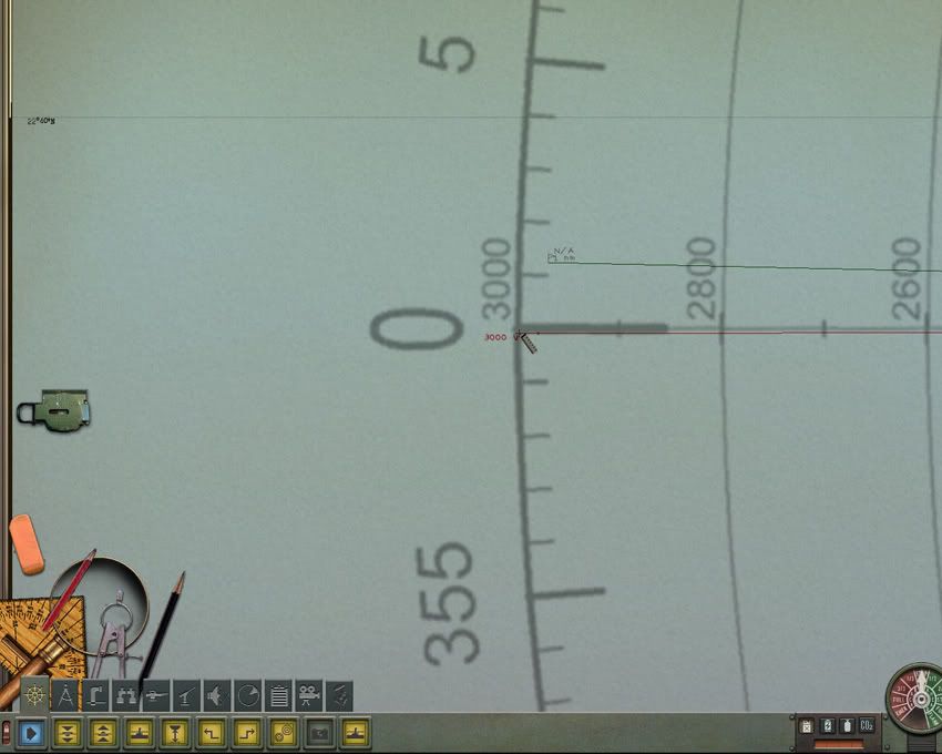 The next image was taken at a 1360x1024 resolution.
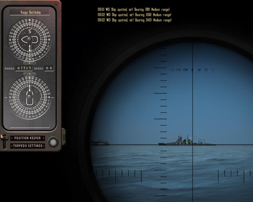
 This is a computer found range of a target listed in the Position Keeper. The Kongo is at 1325 yards.
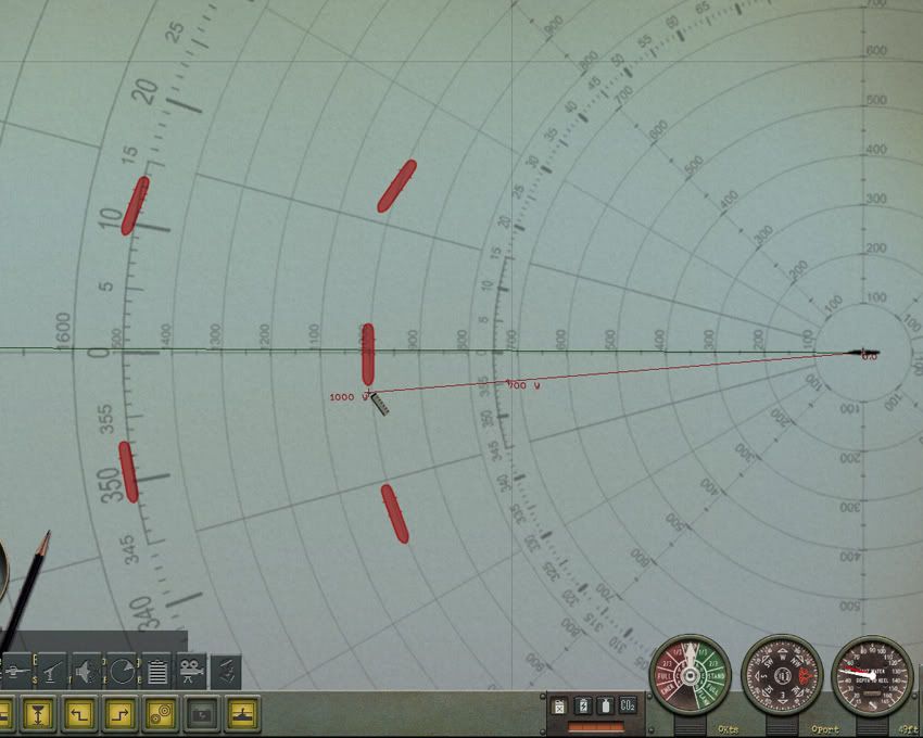
 And the same target as it showed on the navigation map at a 1600x1200 resolution.
 I'm sorry for the large download size. I tried all the tricks I knew but I couldn't get the image size further reduced. Luckily, only one image is used at a time since only one submarine is used at a time. The map screens have limited moving action so the size should not reduce frame rates too much.
__________________

The HMS Shannon vs. USS Chesapeake outside Boston Harbor June 1, 1813
USS Chesapeake Captain James Lawrence lay mortally wounded...
Quote:
|
.."tell the men to fire faster, fight 'till she sinks,..boys don't give up the ship!"
|
Last edited by CapnScurvy; 09-15-10 at 07:16 AM.
|

|

|