
|
|
SUBSIM: The Web's #1 resource for all submarine & naval simulations since 1997
|
SUBSIM: The Web's #1 resource for all submarine & naval simulations since 1997 |
 11-30-07, 03:46 PM
|
#1 | |
|
Admiral
 
Join Date: Apr 2005
Location: Dayton, Ohio
Posts: 2,292
Downloads: 474
Uploads: 64


|
[REL]Ship_Centered_Accuracy_Fix Revisions/Editions as of March 26, 2009
Ship_Centered_Accuracy_Fix 1.4 and 1.5
Compatible with patch 1.4 and 1.5 respectively The latest edition(s) of SCAF have been released April, 2010. Scroll down to check what's new with this icon.  This modification for Silent Hunter 4 changes the target ships manual range finding reference point from the mast, to a more central location. This change will provide a greater amount of accuracy between the sub and target by using structures that are easily seen and have been calibrated for the Stadimeter. The new central positions may use the top of a ships funnel(s), carrier flight deck, top of flag, or other structure to provide this reference point. More importantly, these new positions were calibrated for accuracy with various ship headings and ranges. The changes will provide a needed correction to the stock game data. This correction is good for both metric and imperial game play. For an understanding of why this fix is needed please read the "Discussion" section further down this page. Included within the mod are changes to the Recognition Manual, that have the new reference point marked on the ship with a red pencil. Plus changes to some of the ships pictures for easier identification such as, adding or subtracting guns or funnels as the particular ship is actually displayed. Enlarging and changing the compass, telegraph, and depth dials for easier reading. Adding a Nomograph to the Map page for easier speed finding. Including an optional Metric Nomograph to the download, plus an optional modification that changes the magnification of both periscopes, binocular, and deck gun views, to aid in ship identification and targeting. The U.S. Medals Fix II has also been included with all editions released after March, 2009. This mod should be used with the stock SH4 game files unless otherwise noted. Below are various editions that are compatible with the stock game or modifications that are widely used with the stock game. Just click on the title to go to the link to download. Included is a readme document for proper installation and use. The mod is compatible with the Generic Mod Enabler (JSGME), see it's readme.txt for installation details. Be aware, activating other related mods with this mod may contribute to problems of CTD's or other errors. If a mod does not say it is compatible with another, assume it is not. For Stock Silent Hunter 4 >>>SCAF for SH 1.4 For Stock SH4 patched only to 1.4 Released May 6, 2008. >>>SCAF for SH 1.5 For SH4 version 1.5 Addon Released March 26, 2009. This version is to be used with the U-Boat Missions Addon patched to 1.5 1. A total of 102 ship classes were calibrated for accuracy to include all Axis Warships and merchants, as well as all Allied Warships and merchants. ================= For Trigger Maru Overhauled: >>>SCAF for TMO 1.9 This edition is compatible with the latest patch "TMO19_patch_25012010"released April, 2010 It should be noted that SCAF was incorporated in the TMO 1.7 edition released March 31, 2009. The following editions are for eariler TMO versions. >>>SCAF 1.5 for TMO1.6.3 This edition is to be used with TMO 1.6.2 Full and it's Patch 1.6.3 Released March 26, 2009. Note: If you intend to also use the Run Silent, Run Deep Campaign mod with TMO use one of the below SCAF mods compatible with RSRDC and it's several versions. >>>SCAF for TMO For the older TMO version for SH4 patched only to 1.4 Released Aug. 17, 2008 ================= For Run Silent, Run Deep Campaign: >>>SCAF for RSRDC v502 This edition is compatible to an RSRDC version that is compatible to TMO 1.9. It's also compatible to the "RSRDC_v5xx_Patch"Released April, 2010 It should be noted that SCAF was incorporated in the RSRDC for TMO 1.7 version. It was in the RSRDC_V410_Patch 2A which was released March 31, 2009. The following SCAF editions are for the earlier RSRDC versions. >>>SCAF for RSRD v410 This version is for RSRDC that is compatible to the Trigger Maru 1.6.3 modification. Released March 26, 2009. This version of SCAF 1.5 is compatible with the latest release of RSRDC v410 which is used with the Trigger Maru 1.6.3 modification. The current RSRDC_v410_Patch 2 is also compatible. There have been corrected calibrations made to 154 ship classes with the combined mods. Note: Pre Silent Hunter 4 U-Boat Missions Addon (patch 1.5) Do to the fact that RSRDC does not support any of it's older modifications for a Silent Hunter 4 game patched only to the 1.4 version, I have removed any SCAF mods that were compatable with them. ================= For Real Fleet Boat v2.0 At this time I do not have an edition for the latest RFB edition. ================= MaxOptics The Maxoptics mod will add additional zoom levels to the attack and observation periscopes and increase magnification by 100%. The binoculars and deck gun views were also increased. These versions are for a SH4 game patched to 1.5 (using either the Gold Edition or the U-Boat Missions Add-on) >>> MaxOptics IV for SH4 1.5 This version is for a basic stock SH4 game patched to 1.5 Released March, 2010 >>> MaxOptics IV for TMO 1.9 This version is compatable to the TMO 1.9 and its most current patch 25012010. Released March, 2010 >>> MaxOptics IV for RFB 2.0 This version is compatable to the RFB 1.2 and its most current patch 06Mar10. Released March, 2010 >>> MaxOptics IV for GFO 1.1 Compatable to GFO 1.1 Released March 2010 For Silent Hunter 4 patched only to 1.4 >>> Clayp's Optics for SH4 1.4This version is for the basic stock SH4 game patched to 1.4. Released March , 2010 >>> Clayp's Optics for RFB 1.4 This version is compatable to a Real Fleet Boat 1.4 modification Released March, 2010 ==================== Please read the included readme document for each edition for an explanation of how to correctly install and use ==================== I have a SCAF Range Test mission for comparing the difference between the stock game and SCAF found target ranges. It has three stationary ships, at various distances with a stationary submerged boat. Follow the instructions for testing ranges found by the computer and by manually using SCAF/Stock reference point heights. I also have my handheld AoB Calculator, and a High Realism Tutorial for learning manual targeting and Navigation Map plotting and a Practice Mission for the Tutorial. Discussion Since the rollout of this game, I have wondered why I couldn't hit the broad side of a barn when manually targeting ships. Sure, if you get close enough you can do OK. I however, prefer not to use my sub as a battering ram to sink ships. So I started to test stationary targets, with stationary subs at known distances, set up within the mission editor. At the outset of the games release, the mast heights (which help determine manual found ranges) were kind of a mixture of "I think so", or "Sounds about right", set of values. Maybe there were some set to historical measurements, but historically accurate figures are useless to a game engine that doesn't know how to calculate them. An example was the aircraft carrier Hiryu, which had an original mast height of 20 meters. In my tests at a known distance of 1153 yards, the single mast (which held the flag) gave a manually found range of 650 yards. That's a 503 yard error!! The mast top was only partially visible since it would fade from view with the roll of the ship. The flag which extended into thin air, higher than the mast, showed a range of 624 yards, another quarter of a football field further off, or a 529 yard discrepancy!! Grant you, our developers have made advances toward correcting this. With the 1.3 patch most all mast heights were changed. The 1.4 and 1.5 U-Boat Missions patch has made no changes to the individual ship measurements. The Hiryu now has a mast height of 31 meters. So how does this compare to the above test situation? At the same 1153 yard distance, the top of the flag yielded a range to target of 973 yards, with the top of the mast giving 1008 yards. An improvement, but using those mast height figures you will still miss the correct distance by 1 and a half football field lengths! They say "A miss is as good as a mile", and that's about what you have as a result. With my testing, just less than half the ship's have mast heights that were found to be off by greater than 1 meter, a few by as much as 5 to 8 meters. How much difference does 1 meter height make at a 1000 yards distance? It can be up to 50 yards difference in the actual range found measurement but, the difference will mount up exponential the further away you are. Below is a picture of a U.S. Fleet Carrier showing its computer found range to target as 1611 meters in the Clipboard. 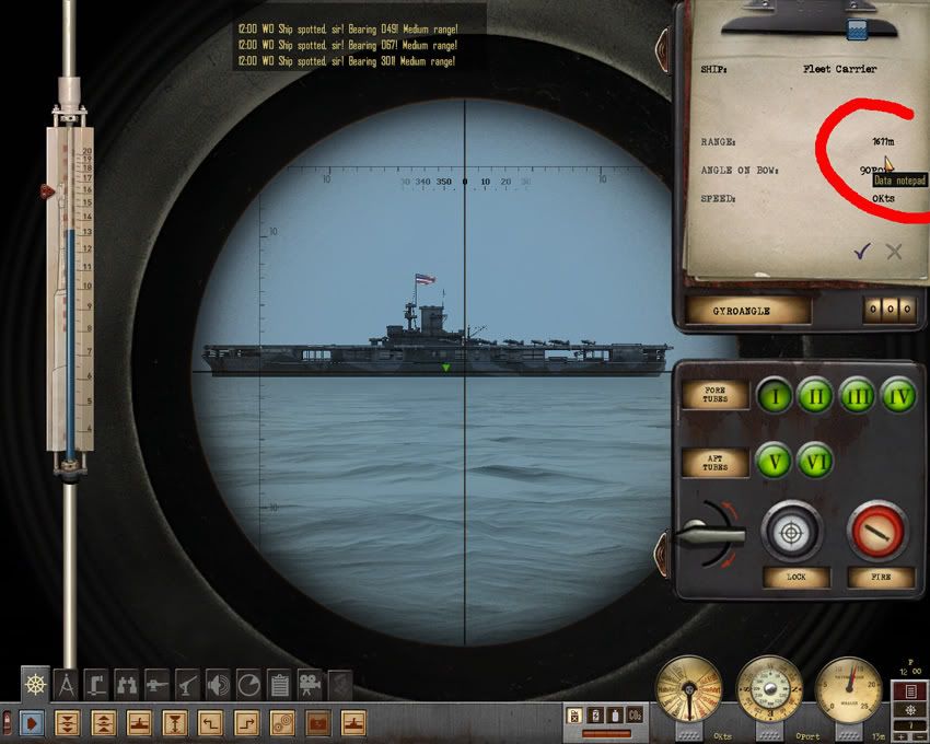 The next picture shows a stock Mast Height of 50 meters in the Recognition Manual, with a manually found range of 1475 meters to target. That's an 136 meter error from the actual distance of 1611 meters. 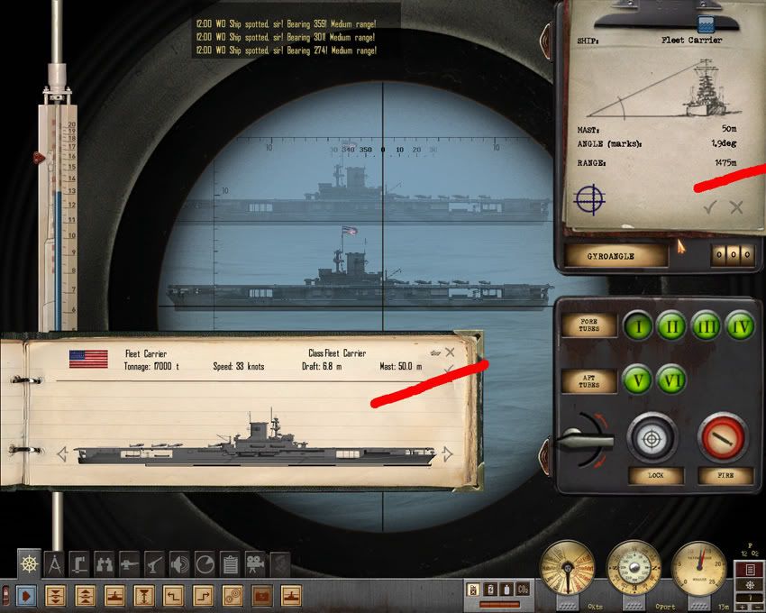 To correct the error the Mast Height should be 54.4 meters high. A 4.4 meter difference from the stock height. The following picture shows the SCAF 1.5 modification activated with the correct Mast Height in the Recognition Manual. Notice the small flag, it tells you the placement of the range finding image's ship waterline should be at the top of the flag. The manually found range is now corrected, with a distance of 1616 meters over the same actual distance of 1611 meters. 5 meters difference at over a 1500 meter distance is like hiting the bulls eye in darts. 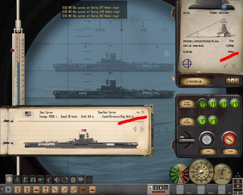 Here's another example using a British River Class DD. It's stock Mast Height is 19.5 meters, with a manually found range of 894 meters. The actual distance from target is 1183 meters, a 289 meter error over a roughly 1000 meter average distance!! 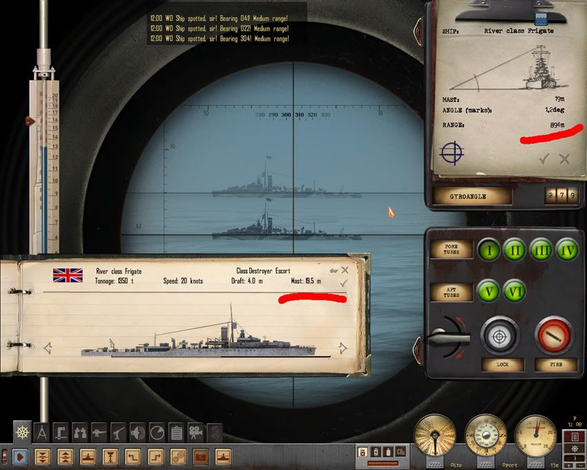 The correct Mast Height should be 25.5 meters. With SACF 1.5 the manually found range to target is now correct at 1182 meters / actual distance 1183. 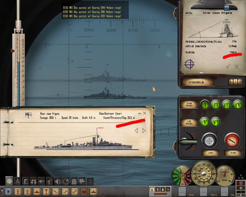 So, you may be asking, are there other ships not having correct mast heights, and by how much are they off? Here are a few other examples: Stock Mast Heights/SCAF Mast Heights Iowa ----------45.5/44.3 Colorado-------42.2/44 N. Carolina-----37.0/32.6 NorthHampton--47.0/49 HogsIsland-----28.0/24.7 Ger. Pocket BB-47.0/37.9 Hiryu CV-------31.0/37.5 Shokaku CV----29.0/32.4 Depending on the various mods that are used, there are specific errors with them that are put into the game, such as TMO: Hiyru CV-------20.0/ 37.5 (this 20 meter figure goes back to before the SH4 Patch 1.3 ?!?) SubChaser-----21.0/17.9 Shokaku CV----29.7/32.4 Bottom line, 1/3 to 1/2 of the mast heights need correcting by over 1 meter or greater. To be fair, there are a few (less than 10) that are correct but, most need tweeking. Lets look at another problem of mast placement. The masts are rarely centered on the ship lengthwise, usually one set towards the bow, the other to the stern. Sometimes there is only one mast such as the following example of the aircraft carrier Taiyo. This picture displays the actual range to target of 1054 yards in the Position Keeper readout using the stock game measurements of the 1.4 patch.  The next picture shows the Stadimeter in use with its second image of the ships waterline on top of the mast. The range was already found once, and shows on the PK as 986 yards. That's a 68 yard difference, which is a lot better than the Hiryu's difference, but not good enough for me. 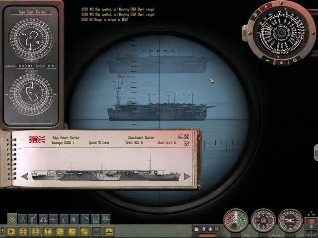 This next picture shows the Ship_Centered_Accuracy_Fix mod enabled. You will note the Recognition Manual has a red line drawn over the flight deck of the carrier. This is the new reference point for the Taiyo. The Stadimeter's image is on the top of the flight deck, centered at the periscope's vertical crosshair. A previous range check has already been taken. The PK reads 1046 yards, just 8 yards difference from the actual distance of 1054. There is a reason why the distance is off 9 yards, which I'll get to later. For the most part that's not bad, considering the distance is greater than 1000 yards. I'll take an 8 yard difference over 68 yards any day. 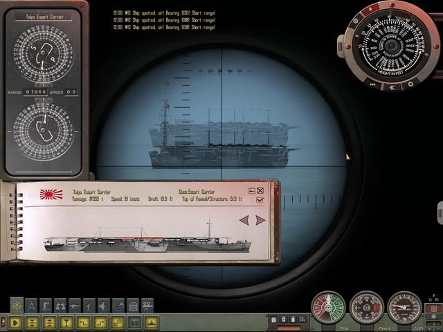 This next example will show the problem of varying mast heights with the light cruiser Kuma. The actual computer found range to target was 1114 yards. [By the way, if you want accurate computer range to target during the game, make sure you do not checkmark the game play option for Realistic Sensors. By going to the sonar station and inputting the view bearing to target onto the right hand bearing wheel, you can receive and send to the PK the actual correct range to target. Just be sure the bearing to target is +/- 2 degrees of the ship, or the sonar will miss its ping.  The above picture shows the taller bow mast with the Stadimeter's image at its top. The range was already checked with a result of 1074 yards showing in the PK. Since the 1.4 patch, the Kuma's mast height is 35.6 meters. But the question is, which mast do you use? The picture below shows the smaller stern mast being checked with a result of 1208 yards to target. Either way, both are a long way from the 1114 actual yard distance. 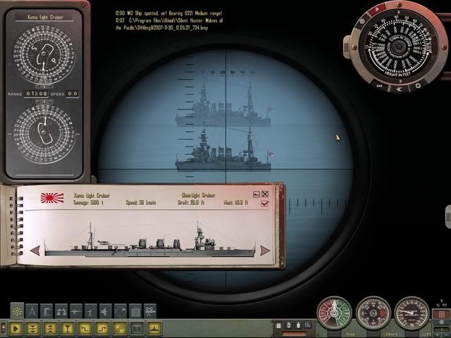 With the Ship_Centered_Accuracy_Fix enabled again, the Kuma has its centered funnel marked as a reference point for the Stadimeter. Placing the water line on top of the funnel, the PK shows the manual found range to be 1114 yards. That's right on the money.  The Recognition Manual ship pictures will aid you in finding the correct reference point for the ships changed. Besides the examples above, other reference points are wires, or ship wheel house roofs. All were chosen to be as close to centered upon the ship and as visible as possible. I mentioned there was a reason why the manually found range on the example above was not exactly on the button to the actual distances. You will note that the ships above were all about 30 degrees AoB. I found during my testing that when a target ship was positioned at 90 degrees AoB (at the same distance) there could be as much as 20 yards difference with the manually found ranges compared to it at 30 AoB. With some ships the difference was less, and others (like the Kuma) no difference at all. I believe the images within the periscope camera changed slightly to produce the difference. How or why I don't know, but a work around is to take an average difference for each ship and have this average your base figure for the Stadimeter to use. It's not perfect but better than the stock game figures. I debated for quite a while why a ship coming towards you at 1000 yards or more, should not give "spot on" correct range compared to a ship at 90 degrees. My conclusion was to settle for the average, giving equal range discrepancy to all possible ship headings. Another problem worth mentioning is the way the Stadimeter reads its position in the periscope camera. As the overlay image is being lowered, you can hear a distinct clicking or ratchet sound representing the pixel horizontal lines that it passes. These pixel lines are defined through the individual ship mast height measurements. The smaller the mast height figure, the smaller the difference between adjacent pixel lines. I wondered why with stationary points (the sub and target ship), a range to target could be as much as 8 to12 yards off with what appeared to be an exact placement of the Stadimeter image. I found I was placing the waterline image just a bit off (onto the adjacent pixel line) due to the image actually changing. One second the top of the reference point image is there, the next it is gone. This difference can be somewhat manipulated by lowering the mast height but, the different camera position will also change to reflect the same basic difference in adjacent pixel lines. In other words the position of the waterline image when set towards the top, middle, or bottom of the periscope image will reflect a smaller, larger, or larger yet (respectively) difference in the range compared to its adjacent pixel line. I've tried to look for this effect within the game files, but a safe answer from me is it's hard coded in the game engine. I believe the reason for this is due to two things. First, a distant ship will appear lower to the waterline than a closer one, thus the closer the ship, the taller the ship within the periscope, the less variance between pixel lines when the Stadimeter is placed towards the top of the screen. Second, the developers designed a bit of realism into this portion of the game by not giving you the exact manual range every time you ask for it. A bit of variability is good for game play. I stated above to place the Stadimeter's waterline overlay image at the center vertical crosshair with the carrier Taiyo. This is important since the basic game calculates distance from ships center to center. You can see this when working with the mission editor. Each ship is positioned and tracked as if it were on an unseen mathematical grid map. The game calculates these positions and can pinpoint the difference with ease. This is why the computer found ranges have always been correct within the game. When manually finding range, a different set of calculations are considered. However, some game aspects stay the same such as the "lock view" to target. The locked view is centered on the target no matter what the different ship angles or headings are. Please keep in mind, not all ships have a convenient centered reference point such as a funnel to use, and not all of them are perfectly centered. But when there are ships that have flight decks or wires that are shown for range finding reference use the vertical center line of the periscope or UZO to match up the overlay image to the reference point. This post is getting way too lengthy. I covered the how, and why. Try it, and see if it doesn't increase your hit percentage with manual targeting. Cheers
__________________
 The HMS Shannon vs. USS Chesapeake outside Boston Harbor June 1, 1813 USS Chesapeake Captain James Lawrence lay mortally wounded... Quote:
Last edited by CapnScurvy; 04-09-12 at 11:51 AM. Reason: Revised version with additional editions for companion mods |
|

|

|
|
11-30-07, 04:32 PM
|
#2 |
|
Watch Officer
 Join Date: Mar 2005
Location: In the North Carolina Sticks
Posts: 335
Downloads: 0
Uploads: 0
|
Looks great, thanks!
|
|
|
|
|
11-30-07, 10:52 PM
|
#3 |
|
Captain
 Join Date: Jan 2004
Posts: 498
Downloads: 2
Uploads: 0
|
Dude, that is sweet. It fixes the prblem with the thin masts not being drawn in or visible and longer ranges...that screws me up all the time for fast movers that dont provide much time for accurate ranging at close range.
|
|
|
|
|
11-30-07, 11:12 PM
|
#4 |
|
Ensign
 Join Date: Nov 2007
Posts: 225
Downloads: 6
Uploads: 0
|
Tried it along with the T.M. 1.7 mod and it does need to overwrite a few things, but, got a CTD after a try out with the torpedoe mission. Probably because of T.M. 1.7 and the recognition manual changes. Looks interesting and will try it without T.M. 1.7 i really like T.M. though.
|
|
|
|
|
12-01-07, 09:28 AM
|
#5 |
|
Ensign
Join Date: Oct 2007
Location: United Kingdom
Posts: 221
Downloads: 41
Uploads: 0
|
Thanks for your hard work on this, looks to be very useful indeed. As to reality, i guess they chose the most appropriate height at the time and input it into the stadimeter, then did the measurements. Is this possible by moving bits on the stadimeter about?
__________________
Rest in peace Dave |
|
|
|
|
12-01-07, 10:47 AM
|
#6 |
|
Commodore
 Join Date: Jul 2006
Posts: 625
Downloads: 5
Uploads: 0
|
ive noticed that you have centered your horizon line with real horizon.
This is not necessary. The Stadimeter in 91KA40T/1.414HA Type periscope was gyrostabilized and this is modeled correctly in game. The horizon line is just a reference but basicly you dont need it for finding range. You can see what i mean in rough sea. Both images are jumping up and down but the difference between them remains. Knowing that makes finding range a lot easier and saves time on fast movers since its one less thing to carry about. All you have to do is to make sure that mast and water line are coincident, forget about the horizon line. |
|
|
|
|
12-01-07, 11:12 AM
|
#7 | |||
|
Admiral
Join Date: Apr 2005
Location: Dayton, Ohio
Posts: 2,292
Downloads: 474
Uploads: 64
|
Quote:
Quite the conundrum indeed. Quote:
__________________
The HMS Shannon vs. USS Chesapeake outside Boston Harbor June 1, 1813 USS Chesapeake Captain James Lawrence lay mortally wounded... Quote:
Last edited by CapnScurvy; 12-01-07 at 05:56 PM. |
|||
|
|
|
|
12-01-07, 01:58 PM
|
#8 |
|
Ensign
Join Date: Oct 2007
Location: United Kingdom
Posts: 221
Downloads: 41
Uploads: 0
|
well what i meant was close to that.
You send the height of the mast (or whatever part) to the stadimeter using the numbers in the manual, before you do the split imaging. What im saying is there a way to manually input the height into the stadimeter, maybe through one of the dials on the stadimeter.
__________________
Rest in peace Dave |
|
|
|
|
12-01-07, 05:40 PM
|
#9 | ||
|
Admiral
Join Date: Apr 2005
Location: Dayton, Ohio
Posts: 2,292
Downloads: 474
Uploads: 64
|
Quote:
__________________
The HMS Shannon vs. USS Chesapeake outside Boston Harbor June 1, 1813 USS Chesapeake Captain James Lawrence lay mortally wounded... Quote:
|
||
|
|
|
|
12-01-07, 08:40 PM
|
#10 | ||
|
Grey Wolf
 Join Date: Jun 2006
Posts: 769
Downloads: 200
Uploads: 0
|
Hi CapnScurvy,
Just a thought, I understood the way the stock range finder works ie against mast height. Was this how the original US range finding system worked, I understood that at least in this regard the US targeting system was quite advanced, (for their day) as compared to other nations. Is the targeting system featured in the game historically accurate? My real question is this: As a former photographer I used Range Finder Cameras, unlike the old, film, not digital SLRs where you focused through the lens, with a range finder you start with two converging images, which gradually you converge until they were exactly superimposed when you were properly focused. I never understood why the US targeting system was calibrated against mast height when perhaps it would have been easier, not to mention quicker to set range by simply adjusting two opposing images of the target in the perescope view until they were superimposed exactly, and you took your range from the resultant sharply focused image. What I'm trying to say is why stop at the deck height or smoke stack height, why not just set your system by the direct focus system I'm trying to describe above. Hope I am describing the concept so folks can understand what I'm trying to describe Regards Rascal Quote:
|
||
|
|
|
|
12-01-07, 09:32 PM
|
#11 | |
|
Commodore
Join Date: Jul 2006
Posts: 625
Downloads: 5
Uploads: 0
|
Quote:
If you are interested in details how the stadimeter and periscope worked i suggest reading this: http://www.hnsa.org/doc/fleetsub/index.htm very interestning find if you want to study every screw and bolt of the fleet type submarine ;-) Including pretty detailed description of its optics, its in periscope manual. By the way... looking at this ive found a very interestning detail. Looks like the stadimeter was not just able to find range by displacing two pictures verticaly. It could also be moved horizontaly to find AoB. To bad its not in game. But to your question. The method you are talking about is just and simple not acurate enough. It becomes very inacurate at great ranges. And they took masts as reference points because they returned the highest angles. They wanted the reference angle as high as possible because it made the calculations more acurate. And remember they had no problems with limited screen resolutions :-) |
|
|
|
|
|
12-01-07, 09:45 PM
|
#12 | ||
|
Admiral
Join Date: Apr 2005
Location: Dayton, Ohio
Posts: 2,292
Downloads: 474
Uploads: 64
|
Quote:
For your second question, I do understand. Its been a long time, but I seem to remember a sub game that did just as you describe. It overlayed the image with a blurry one, and once focused you could get the estimated range to target. I don't wish to sell anyone short within this community who could correct me for saying this but I don't think the capabilities of changing SH4 to this type of game play could be done outside the game developers. I'm sure I could not.
__________________
The HMS Shannon vs. USS Chesapeake outside Boston Harbor June 1, 1813 USS Chesapeake Captain James Lawrence lay mortally wounded... Quote:
|
||
|
|
|
|
12-01-07, 10:11 PM
|
#13 | |
|
Commodore
Join Date: Jul 2006
Posts: 625
Downloads: 5
Uploads: 0
|
Quote:
So to answer your question. It is very good modeled in sh4. They had all this. Position keeper, stadimeter (even more powerfull one that could find AoB too) all these tools. Actualy they had even more toys then what we have so firing solutions were pretty advanced at that time id even say they had it easier. They had other problems though. They didnt have data for every ship. Often they had to guess the mast high, lenght and draft. It sounds like a very inacurate method but guessing a size of a ship is not that hard. Its easier in real world because a simulation can never convey the right proportions to our eyes. Just look outside your window and try to guess a size of something big (bridge/house etc) you will see you are pretty good ad guessing sizes. Expirenced submariners are even better at guessing the size of ships. And thats were they needed the vertical marks in optics. When they had to guess the high of unknown vessel. They used the marks for reference on something which size they would guess best. Example. youre trying to guess the mast high of unknown vessel. You look at it and find a seaman smoking on deck. You know that a seaman is about 5 feet tall. So you try to fit him between two marks. When you found something he fits in just count how often you can put a 5 feet tall seaman into the mast. Of course sometimes there are no seaman on decks but then you can just take containers, cars/tanks or anything else... edit: irony of destiny - if that seaman smoking on deck was just a head taller, that might have saved his life :-) |
|
|
|
|
|
12-02-07, 09:45 AM
|
#14 | ||
|
Admiral
Join Date: Apr 2005
Location: Dayton, Ohio
Posts: 2,292
Downloads: 474
Uploads: 64
|
Thanks WernerSobe for the answers.
I just had no idea how advanced the TDC really was for a WWII sub. You mentioned the original devices calculated the Aob as well. That is one reason why I tried to center the reference points as much as possible on the target ship. The game could have used the AoB bearing inputted through the Attack Data Tool for figuring the difference in mast placement comparied to the center of the ship, but it doesn't. It's probably just as well, there would have been another calculation required to find range. So, you get a different range finding because of the off centerd position of the mast. Quote:
__________________
The HMS Shannon vs. USS Chesapeake outside Boston Harbor June 1, 1813 USS Chesapeake Captain James Lawrence lay mortally wounded... Quote:
|
||
|
|
|
|
12-02-07, 11:14 AM
|
#15 | |
|
Torpedoman
 Join Date: Apr 2007
Location: fl
Posts: 112
Downloads: 0
Uploads: 0
|
Quote:
great job, Thanks |
|
|
|
|
 |
|
|


 Linear Mode

