SUBSIM Radio Room Forums


SUBSIM: The Web's #1 resource for all submarine & naval simulations since 1997

Go Back   SUBSIM Radio Room Forums > Silent Hunter 3 - 4 - 5 > SHIII Mods Workshop
Forget password? Reset here

Reply
 
Thread Tools Display Modes
Old 06-10-17, 02:50 PM   #136
Kendras
Stowaway
 
Posts: n/a
Downloads:
Uploads:
Default

I need to open .raw files but I don't have photoshop ....
  Reply With Quote
Old 06-10-17, 03:04 PM   #137
Kendras
Stowaway
 
Posts: n/a
Downloads:
Uploads:
Default

Quote:
Originally Posted by gap View Post
...but as I said before, your clean drawing will make little difference once it is scaled down to fit in the small space of SHIII's terrain masks.
Yes, probably for the terrain. But it will be very useful to build the harbour !

Here what it looks like with 200x200 meters for each pixel :


Last edited by Kendras; 06-10-17 at 03:19 PM.
  Reply With Quote
Old 06-10-17, 04:33 PM   #138
gap
Navy Seal
 
Join Date: Jan 2011
Location: CJ8937
Posts: 8,214
Downloads: 793
Uploads: 10
Default

Quote:
Originally Posted by Kendras View Post
I need to open .raw files but I don't have photoshop ....
Don't GIMP or paint.NET have a raw file plugin?

Quote:
Originally Posted by Kendras View Post
Yes, probably for the terrain. But it will be very useful to build the harbour !
Who will notice if the harbour is stretched out a bit?

Quote:
Originally Posted by Kendras View Post
It's very easy to get the exact coordinates of a lighthouse with the mission editor.
Sure, but what would happen if where it was supposed to be land, there is only water?

Quote:
Originally Posted by Kendras View Post
I already though about that question, and I don't see how to do this (halo with different colors depending on the angle). And I don't understand the link between angles on charts, and equirectangular projection.
I need to think a way to do it

Quote:
Originally Posted by Kendras View Post
I hope so too ! By the way, are you still working on the british coastal defenses ?
Sure, the working files are still on my HD
__________________
_____________________
|May the Force be with you!|
...\/
gap is offline   Reply With Quote
Old 06-10-17, 05:32 PM   #139
Kendras
Stowaway
 
Posts: n/a
Downloads:
Uploads:
Default

The islands would be so better rendered with 50x50 meters squares ! ...

Quote:
Originally Posted by gap View Post
Don't GIMP or paint.NET have a raw file plugin?
For now, the plugins I've tried don't work with Paint.net.

Quote:
Originally Posted by gap View Post
Sure, but what would happen if where it was supposed to be land, there is only water?
This will never happen, because we will first check the altitude with a land unit, which also will give us the exact location.

Quote:
Originally Posted by gap View Post
Sure, the working files are still on my HD
Ready to share ?
  Reply With Quote
Old 06-10-17, 06:34 PM   #140
gap
Navy Seal
 
Join Date: Jan 2011
Location: CJ8937
Posts: 8,214
Downloads: 793
Uploads: 10
Default

Quote:
Originally Posted by Kendras View Post
The islands would be so better rendered with 50x50 meters squares ! ...
Who knows if we can replace the SHIII terrain with the one of SH5? Apparently the two games share the same terrain format, but even if it worked, probably all the harbors and terrain objects would be messed up

Quote:
Originally Posted by Kendras View Post
For now, the plugins I've tried don't work with Paint.net.
Try with GIMP then. I have PS, but apparently we have different ideas on how to edit those raw maps

Quote:
Originally Posted by Kendras View Post
This will never happen, because we will first check the altitude with a land unit, which also will give us the exact location.
Yes sure, there are different ways to do it, but again this is the trial and error method I wanted to avoid...

Quote:
Originally Posted by Kendras View Post
Ready to share ?
Not yet. I didn't work on it in a long time, and I still have many pending projects, but if you want it I might move it toward the top of my todo list
__________________
_____________________
|May the Force be with you!|
...\/
gap is offline   Reply With Quote
Old 06-10-17, 06:48 PM   #141
Kendras
Stowaway
 
Posts: n/a
Downloads:
Uploads:
Default

Quote:
Originally Posted by gap View Post
Who knows if we can replace the SHIII terrain with the one of SH5? Apparently the two games share the same terrain format, but even if it worked, probably all the harbors and terrain objects would be messed up
The best solution would be that you create the 3D model of the islands.
  Reply With Quote
Old 06-11-17, 02:36 AM   #142
the_frog
Commander
 
Join Date: Nov 2010
Posts: 456
Downloads: 17
Uploads: 0
Default

Quote:
Originally Posted by Kendras View Post
The best solution would be that you create the 3D model of the islands.
Kendras, why not starting right away?
the_frog is offline   Reply With Quote
Old 06-11-17, 04:35 AM   #143
Kendras
Stowaway
 
Posts: n/a
Downloads:
Uploads:
Default

Quote:
Originally Posted by the_frog View Post
Kendras, why not starting right away?
Are you offering your help to create Helgoland islands 3D model ?

I'm not competent at all in 3D modeling and texturing. The only things I can do for this mod are :

- give ideas
- make researches
- make in-game tests
- add the lighthouses locations
- create harbours
  Reply With Quote
Old 06-11-17, 05:24 AM   #144
Kendras
Stowaway
 
Posts: n/a
Downloads:
Uploads:
Default

Interesting tutorial :


Edit : Unfortunately, Helgoland is not represented on height maps of terrain.party.

Last edited by Kendras; 06-11-17 at 05:57 AM.
  Reply With Quote
Old 06-11-17, 08:08 AM   #145
gap
Navy Seal
 
Join Date: Jan 2011
Location: CJ8937
Posts: 8,214
Downloads: 793
Uploads: 10
Default

Quote:
Originally Posted by Kendras View Post
The best solution would be that you create the 3D model of the islands.
Quote:
Originally Posted by the_frog View Post
Kendras, why not starting right away?
Quote:
Originally Posted by Kendras View Post
Are you offering your help to create Helgoland islands 3D model ?
Kendras, I am afraid making islands bigger than a rocky islet into 3D objects, is not the most efficient way to bring them in game.
Talking about Helgoland and Düne, what for sure can be done is creating a basic terrain representation of them (with the known limitations) and adding to them custom harbor models with fairly realistic docks, breakwaters, buildings etc. The historical pictures you have collected so far will be a valid help, and who cares if the final result wont be 100% identical to the real thing?
After all, the whole SH world is a simplified/distorted representation of the globe, but we still enjoy exploring it!

Quote:
Originally Posted by Kendras View Post
Interesting tutorial :

Edit : Unfortunately, Helgoland is not represented on height maps of terrain.party.
I dont have Unity, but the heightmap interpolation can be done with similar results in Blender.
The website is cool, but at the moment only Americas and the westernmost portion of Europe is available. Even so, I tried exporting height dat for the Île de Sein, but all I got is a dark grey map. There are various other websites that heightmaps of the globe can be downloaded from, but unfortunately getting height information at such a small scale is pretty hard.
__________________
_____________________
|May the Force be with you!|
...\/
gap is offline   Reply With Quote
Old 06-11-17, 08:35 AM   #146
Kendras
Stowaway
 
Posts: n/a
Downloads:
Uploads:
Default

Quote:
Originally Posted by gap View Post
I dont have Unity
Pretty impressive ! Watch this :

  Reply With Quote
Old 06-11-17, 08:48 AM   #147
Kendras
Stowaway
 
Posts: n/a
Downloads:
Uploads:
gear

Gap, in order I create harbours at the proper scale, could you create a small "tool" for me ? It would be a simple 3D object (a box) which allows me to measure distances in S3D. So I would like it to be 1 meter high, 10 meters large, and 500 meters long.

* on the 500 meters side, you add marks each 50 meters. The first 50 meters are also divided with small marks each 10 meters. The first 10 meters space is itself divided each 1 meter.

* the 10 meters side is marked each 1 meter. At 5 meters, the mark is longer.
  Reply With Quote
Old 06-11-17, 09:10 AM   #148
Kendras
Stowaway
 
Posts: n/a
Downloads:
Uploads:
Default

1. A little comparison with the actual Helgoland in SH3.


2. Even that simple model would be better :
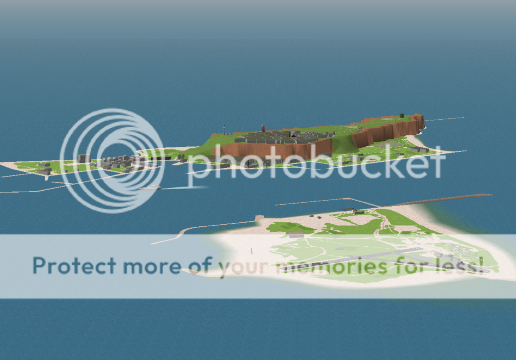
  Reply With Quote
Old 06-11-17, 11:30 AM   #149
Kendras
Stowaway
 
Posts: n/a
Downloads:
Uploads:
Default

I think Helgoland is not the priority for now. I may try to add your models on the existing terrain. But the LH and light signal placed on Düne must be placed on a land model (covered with sand), because if I place them at the right place, they will be in the water (see my previous post).

Let's concentrate on the french LH. Perhaps the LH of "La Vieille" could be tested in game very soon ?
  Reply With Quote
Old 06-11-17, 12:34 PM   #150
the_frog
Commander
 
Join Date: Nov 2010
Posts: 456
Downloads: 17
Uploads: 0
Default

GWX and all big Mods include a map version (I think created by Tigerkatzitatzi) that gives an "improved" representation of Helgoland + Döne. It is not prefect but better than nothing.


Quote:
Originally Posted by Kendras View Post
I think Helgoland is not the priority for now. I may try to add your models on the existing terrain. But the LH and light signal placed on Düne must be placed on a land model (covered with sand), because if I place them at the right place, they will be in the water (see my previous post).

Let's concentrate on the french LH. Perhaps the LH of "La Vieille" could be tested in game very soon ?
the_frog is offline   Reply With Quote
Reply


Posting Rules
You may not post new threads
You may not post replies
You may not post attachments
You may not edit your posts

BB code is On
Smilies are On
[IMG] code is On
HTML code is Off

Forum Jump


All times are GMT -5. The time now is 09:44 PM.


Powered by vBulletin® Version 3.8.11
Copyright ©2000 - 2024, Jelsoft Enterprises Ltd.
Copyright © 1995- 2024 Subsim®
"Subsim" is a registered trademark, all rights reserved.