SUBSIM Radio Room Forums


SUBSIM: The Web's #1 resource for all submarine & naval simulations since 1997

Go Back   SUBSIM Radio Room Forums > Silent Hunter 3 - 4 - 5 > SHIII Mods Workshop
Forget password? Reset here

Reply
 
Thread Tools Display Modes
Old 04-19-16, 07:21 PM   #16
Rick Fortens
Watch
 
Join Date: Jul 2009
Location: Québec city
Posts: 23
Downloads: 365
Uploads: 0
Default

Quote:
Originally Posted by Tycho View Post
I don't see any of your screenshots, here and in the first post.

And now ?


And, here you lost me.
In the kriegsmarine system of squares to devide the ocean the North sea is usualy named "AN". Look on the nav map in the game.
Rick Fortens is offline   Reply With Quote
Old 04-19-16, 07:35 PM   #17
Rick Fortens
Watch
 
Join Date: Jul 2009
Location: Québec city
Posts: 23
Downloads: 365
Uploads: 0
Default

Quote:
Originally Posted by Von Due View Post
I would be VERY interested in having a look at work done to make a curved world surface, if only for the North Atlantic, and, one can dream, the arctic ocean.
Have you been able to see my screenshots ?

For the artic ocean, I can’t be of any help, but if you are interested in my works, no problem : just tell me what you want to know or see about.
Rick Fortens is offline   Reply With Quote
Old 04-20-16, 02:45 AM   #18
Tycho
Sonar Guy
 
Join Date: Oct 2009
Location: Sofia, Bg
Posts: 384
Downloads: 264
Uploads: 1


Default

Quote:
Originally Posted by Rick Fortens View Post
And now ?
Yes, now are visible.

Quote:
Originally Posted by Tycho View Post
And, here you lost me.
Quote:
Originally Posted by Rick Fortens View Post
In the kriegsmarine system of squares to devide the ocean the North sea is usualy named "AN". Look on the nav map in the game.
I mean, that if Kriegsmarine grids are not correct, it is not interesting anymore for me.

Quote:
Originally Posted by Fahnenbohn View Post
How did you do that ?!
I think that Photoshop open it, but I don't use Photoshop.
So I make it with PaintNet as .tga, and then convert it with another software.
If you are interested, will show you tonight.

Quote:
Originally Posted by Fahnenbohn View Post
Are they many errors in the stock SH3 game about climate zones ??
I don't know. Because I made complete new one, have not examined in detail the original file. Well, I saw some shades that are not indexed in Terrain.cfg, but it's just a pixels here and there, in such a places that I will not go to the Machu Picchu cornfields to see what happen there.
__________________
If you ride like lightning, you're gonna crash like thunder.
Tycho is offline   Reply With Quote
Old 04-20-16, 03:20 AM   #19
Anvar1061
Ocean Warrior
 
Join Date: May 2012
Location: In the sea, on land and above
Posts: 3,344
Downloads: 846
Uploads: 0
Default

Quote:
Originally Posted by Tycho View Post
Just some days ago I made my own TerrainTypes.raw (Climate zones).
Where you can download them?
Anvar1061 is offline   Reply With Quote
Old 04-20-16, 04:13 AM   #20
Fahnenbohn
Ace of the Deep
 
Join Date: Sep 2013
Location: France
Posts: 1,072
Downloads: 155
Uploads: 0
Default

Quote:
Originally Posted by Tycho View Post
I think that Photoshop open it, but I don't use Photoshop.
So I make it with PaintNet as .tga, and then convert it with another software.
If you are interested, will show you tonight.
Yes i am. You're thinking about teamviewer ?
Fahnenbohn is offline   Reply With Quote
Old 04-20-16, 02:58 PM   #21
Tycho
Sonar Guy
 
Join Date: Oct 2009
Location: Sofia, Bg
Posts: 384
Downloads: 264
Uploads: 1


Default

Quote:
Originally Posted by Fahnenbohn View Post
Yes i am. You're thinking about teamviewer ?
Sorry, I came home too late, terrain types thing will wait for tomorrow.
__________________
If you ride like lightning, you're gonna crash like thunder.
Tycho is offline   Reply With Quote
Old 04-21-16, 10:47 AM   #22
Fahnenbohn
Ace of the Deep
 
Join Date: Sep 2013
Location: France
Posts: 1,072
Downloads: 155
Uploads: 0
Default

Quote:
Originally Posted by Tycho View Post
Sorry, I came home too late, terrain types thing will wait for tomorrow.
ok for this evening ?
Fahnenbohn is offline   Reply With Quote
Old 04-21-16, 05:04 PM   #23
Tycho
Sonar Guy
 
Join Date: Oct 2009
Location: Sofia, Bg
Posts: 384
Downloads: 264
Uploads: 1


Default

Quote:
Originally Posted by Fahnenbohn View Post
ok for this evening ?
Sorry for delay: here
__________________
If you ride like lightning, you're gonna crash like thunder.
Tycho is offline   Reply With Quote
Old 04-26-16, 06:24 PM   #24
Zenpachou
Stowaway
 
Posts: n/a
Downloads:
Uploads:
Default

Holy cow. I knew the world map was distorted, but I had no idea it was to that extent
  Reply With Quote
Old 04-28-20, 03:36 AM   #25
shadow_wxh
Soundman
 
Join Date: Mar 2017
Posts: 142
Downloads: 107
Uploads: 1
Default

This is one of the major problem affect game realism.The further you go north or south the more east-west distance are strentched.This make almost the long distance travel time inaccurate by a huge factor.

One way the navy plot were made is too strentch both north-south and east-wast as you move towards earth poles.This way the bearings getween objects are reserved but the distances can not be directly measured.Like these ones:


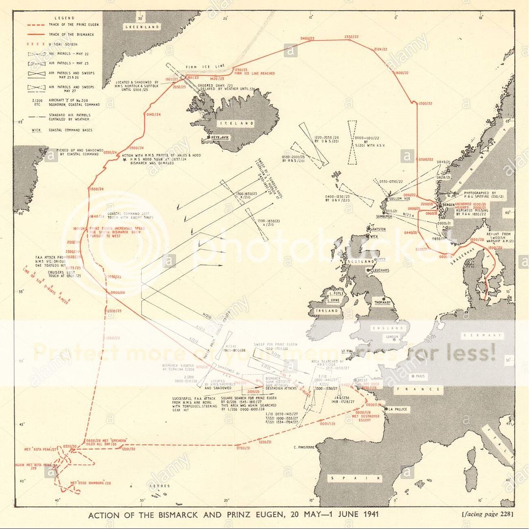
The way SH3 simulate the enviroment compromise both.Neither distances nor bearings are accurate.This makes plotting in champain file really difficult to resemble actually historical time the place.

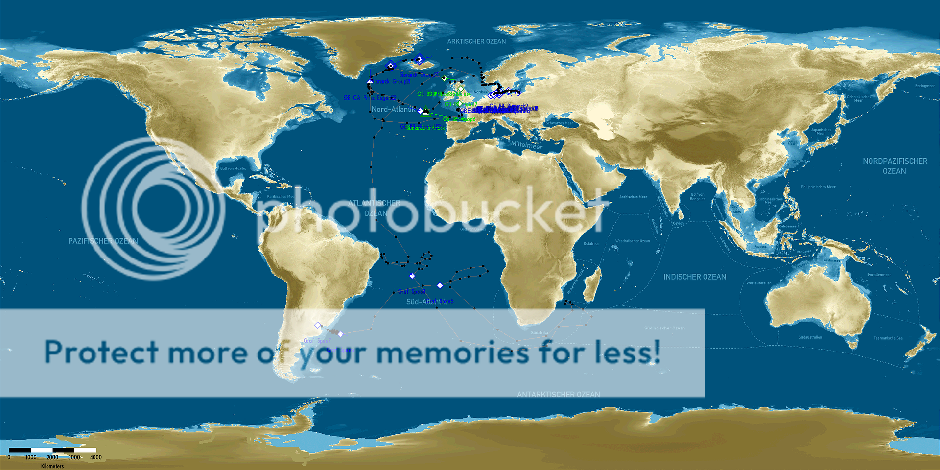
One way I overcome the issue is make a few "jumps" alone the waypoints the compensate the distance strenches,but this is not a very good solution.Still wondering if it is possible to resolve this by modification alone.
shadow_wxh is offline   Reply With Quote
Reply


Posting Rules
You may not post new threads
You may not post replies
You may not post attachments
You may not edit your posts

BB code is On
Smilies are On
[IMG] code is On
HTML code is Off

Forum Jump


All times are GMT -5. The time now is 08:32 PM.


Powered by vBulletin® Version 3.8.11
Copyright ©2000 - 2024, Jelsoft Enterprises Ltd.
Copyright © 1995- 2024 Subsim®
"Subsim" is a registered trademark, all rights reserved.