Good Evening!
First off, my appologies for the length. I just figured I'd add the changelog I have so far. It covers what I'm up to in the project. I basically just do a little here and a little there when I get a chance to after getting home from work.
So far this is what I have:
CHANGELOG - As of 03-NOV-2023
=============================
1. Changed all the vessel codes to match the ONI codes used by the U.S.N. during World War II.
-- Still have to finish the listing, but it's getting there.
-- Finished the default ship listing and the FotRSU listing.
-- Still need to finish the Nipon Maru and the Nihon Kaigun listing.
2. Changed classification of some vessels to represent historical names.
-- "Fleet Carrier Saratoga Class" changed to (CV) Lexington Class
-- "Fleet Carrier Enterprise Class" changed to (CV) Yorktown Class
-- etc, etc.
3. Added "Length:" and "Asp. Ratio:" fields to the name of the ship. This gives the data to the user so that speed and AOB calculations will be much simpler to compute.
-- The ship's names now appear on the navigation map and targeting map as well, as long as they are identified and selected (All information now appears as being "written" on the maps).
-- Gives a better ability to get the AOB more accurately, which can -- in turn -- help have a better estimate of target course when combined with periscope bearing and own sub's heading.
4. Changed the grammaphone into an updated "Targeting Assistant" with various formulae and data that is useful in computing targeting manually. Also added a "sinus scale" to the grammaphone, courtesey of "Hitman" who came up with the original in his tutorial on how to target ships using 100% realism.
-- Work is taken from the "Targeting Assistant V1" work I've already done and, in essance, will replace that release. The other one can still be used independantly, just not with this release since the files in this package will replace that grammaphone.
5. Added "Hitman"'s "TSAC Scale" to the attack map so that you can find the spread angle for torpedo shots using the length of the ship and the bearing.
-- Also made the TSAC a little bigger for wide-ratio screen resolutions.
-- Requires you to download and activate Hitman's file first, then activate the "ini" file which I'll include with the "Targeting Assistant" in order to change the size/ratio in the "menu_1024_768.ini" file using the Jimimadrid MenuMerger program.
6. Updated the Recognition Manual so there is a section labeled "U.S.N. Hull Classifications".
-- Gives the user the ability to decipher the new hull codes used in the manual.
-- Example: CV=Fleet Carrier, PG=Gunboat, ATF=Fleet Tug Boat, AK=Cargo/Freighter, etc.
-- Basically a new "country" that uses fake "ships" to represent the information in what are the sillouette pages.
-- The "flag" is on an index card and it now reads, "BuC&R/BuShips -- Ship's Data: U.S. Naval Vessels"
-- Data taken from Wikipedia, but is actually the data used by the Bureau of Construction and Repair -- later Bureau of Ships -- to identify ships. Uses codes used/active during WW2.
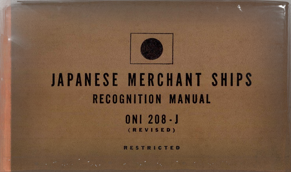
7. Changed the "MERCHANT SHIPPING" label (flag) to an index card that reads, "ONI-209 CLASSIFICATION FOR MERCHANT SHIPPING".
8. Enlarged the manual itself by changing the scalar ratio in the "Zone" line to "1" instead of "0" as originally written.
-- Original idea given to me by Mazzi at Subsim, though I had to change his suggestion values. Thanks, Mazzi!
-- As with the Hitman overhaul of the TSAC, this is part of the lines included in the "ini" file activated with Jimimadrid's MenuMerger program.
9. Updated all ships to include those from the default listing, FotRSU 1.8, Nihon Kaigun, and Nippon Maru 1.8 (inclusive).
-- NOTE: Still need to finish the listings. Not all sections/ships complete yet. See above.
10. Created a PDF file with all the information in the "U.S.N. Hull Classifications" listing for the manual so that users can print out a hard-copy if they choose.
-- Same information in the Recognition Manual, but in a "printer-friendly" version which is just text and won't "kill" your ink supply (other than black, at least).
11. Changed the radio from the strategic map over to something that contains various data elements to help in identifying ships. Charts there were taken from a PDF version of an original ONI-223-M manual and cobbled together as best I could figure while still maintaining readable fonts and pictures of the originals.
-- I can't remember where I got the ONI-223-M manual from. May have been from the Navy's Historical Command database, but can't remember.
-- There is other data and other manuals I got from the Ibiblio.org website (hyperwar) as well as from the USS Pampanito website (maritime.org). Thanks to all for making all this data available to us.
12. Added a chart to the radio that allows a generic estimation of tonnage of an observed vessel. According to the ONI-223-M manual, this should be good enough for about 80% of all merchant vessels in service at the time.
-- I tested it against some of the ships in-game, and it seems to work fairly well in estimating the tonnage. Most I was off was 1,000 tons or so.
-- I may delete this since it takes up a good chunk of the space and the "tonnage" is already in the manual itself when you get to the ship. I just figure this would be good enough for estimating the tonnage from reading the "name" written on the navigation map if identifying with the weapons officer (yes, FotRSU has a button for that).
13. Changed the "Cooler" ships to reflect what it should have said to begin with -- "Coaler". These were coal-transports known in USN parlance as, "Colliers" instead. Hull Code: AC.
-- Curiosity Note: The two most famous colliers/coalers were the "U.S.S. Jupiter" and the "U.S.S. Cyclops". The "Cyclops" was lost at sea between Trinidad and NYC, and is the first of the famous "Bermuda Triangle" losses. The "Jupiter" was renamed "Langley" and became the first aircraft carrier in the U.S. Navy.
-- Some, not all, colliers/coalers were used as "bulk fuel/oil" carriers. What this means is that the holds were filled with palletized 55-gallon drums of diesel or gasoline and transported like regular cargo. Probably not the best idea, but a similar thing was done with whale factory ships.
14. Repositioned the flags in the actual pages of the manual. These are the ones that are at the top-left of the manual when you actually go to a ship's page. The original setting had the flag covering the "ONI 41-42" tag at the top left.
-- The flags are now placed just below the title and centered vertically between the "ONI 41-42" tag and the sillouette of the ship below.
15. Thanks to Daniel Coffey and his work on the sillouette info way back when. It made things MUCH easier to do when making the changes for the manual.
16. Figured out how to add the great plastic cover image used in Dark Waters for the navigational map into the map for the US fleetboats and S-Boats.
-- Need to find who I need to ask permissions from in order to release, however. All credits have to go to whomever put that thing together, otherwise it's just for my own use. Sorry.
-- Mainly wanted it as an optional thing for the S-Boats and early fleet boats (Narwhal, Cachalot, etc.) that have the condensation dropplets all over the place when you're submerged. I just thought it would be a nice touch to the map since it would make sense to have.
17. Managed to create monochrome versions of ALL the flags for the manual cover. It now looks like you have a bunch of index cards with either printed monochrome flags for the countries involved, or it has something typed to signify what is being covered in the sub-pages.
-- This is the same index card used for the written labels I've mentioned already, but with a monochrome flag instead of writing.
-- Uses only naval ensigns and not the national flags as before.
-- In the case of France, the ensign is the one with the different width ratios for the vertical stripes. This means it's accurate when compared to the French national flag which is equal-ratio.
As for some screenshots, this is from earlier in the week.
New page for the fake country I made to accomodate the hull classification system:

This is the new "MERCHANT SHIPPING" page I mentioned above:

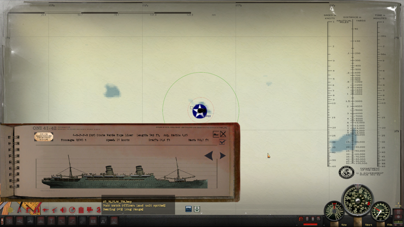
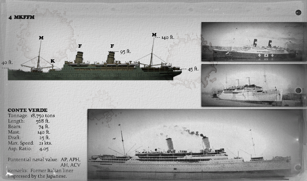
And an example of a finished section in final format. Here's the "Conte Verde" ocean liner that was requisitioned by the Japanese at the beginning of the war:
Here are some of the flags. U.S. and Japan in this case:


Unfortunately they lose some quality when shrunk down to fit (128x64 isn't really that big), but they can still be used and don't look too bad.
As you can see by the shots (and the comments above), I've managed to add the plastic cover from Dark Waters to the navigation map. If anyone knows who I would need to PM or contact for permission to release with this as part of the mod, please let me know. Otherwise I won't include it.
The plan is to spend the next few days working on the coding for the "Nipon Maru" ships. I have the entire ONI-208-J from the Pampanito website downloaded. I've made a few images as "test" subjects. If I can figure out how to actually add another "page/group" to the HUD (and the menu "ini" file as well), then I can add a whole new "book" for the sim.
Here are some shots of what I have so far. WIP, no doubt, but still not too bad:


This is an example of how you could have a page for a ship, in this case the "Conte Verde" with the sillouette from the game cropped to "1-pixel=1 foot" and marked with dimensions where I thought would be the easiest things to see through the scope or the TBT:
I don't know if there would be an interest in this, but it would definately be a challenge for a V2.
At the very least, I could work on it AFTER the manual updates and make it into a PDF file that could be uploaded in various chapters. That way, even if I couldn't program another button or "page" for this, I could at least get the work out there if there was any interest.
Hope everyone enjoys their Friday!
Regards,
ElCid97